
Geographical hints: - Kannur district was formed in January 1,1957, 87Km Seashore. Sahya Mountains at the border parallel to seashore. Rivers:There are seven important rivers. Total forestland in the district: 48,734.
On to the North of Kerala, sandwiched between the Western Ghats and the Arabian Sea, lies Kannur, anglicised as Cannanore. This stretch of land, with every inch in history, has been a melting pot of races, religions and cultures from time immemorial. Relics, right from the Neolothic age through the Aryan invasion, Cheran Conquests, Arab and European inroads, stand testimony to this.
Apart from greenery and beaches, Kannur invites tourists to these monuments of Time-to feel the grave quietness and the tranquility of the past and to share the warmth and cordiality of its peaceful and soft spoken people.
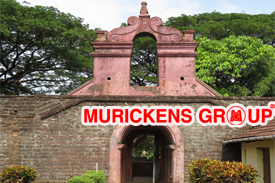
This historical fort, built in 1505 AD by Sir Fancisco DeAlmeiyda, the first Portuguese Viceroy of India,, is situated near the sea coast about 2 KM away from Kannur town.
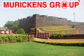 This fort has a legendary past. Having witnessed several wars for seizing the control of the fort, the British flag flew over it finally in 1790.In 1498, during Vasco da Gama's visit to India, the local Kolathiri king granted the land to Portuguese to build a settlement in present-day Kerala. On 23 October 1505, he gave the Portuguese leader Francisco de Almeida the permission to build a fort at the site. The fort provided naval supplies for the Portuguese conquest of Goa and the Portuguese conquest of Malacca. As the local Portuguese settlement at Kannur had no sources of revenue, the fort's expenses were met with funding from Goa, the seat of Portuguese rule in India.
On 15 February 1663, the Dutch captured the fort from the Portuguese.They modernised the fort and built the bastions Hollandia, Zeelandia and Frieslandia that are the major features of the present structure. The fort is in the Cannanore Cantonment area. It is fairly well preserved as a protected monument under the Archaeological Survey of India. St Angelo's fort is a most important historical monument and a popular tourist attraction. Six Tourism Policeman are posted here for protection duty.In 2015, thousands of cannonballs weighing several kilos were discovered from the Fort premises. The Archaeological Survey of India, which led the excavation, believes these were buried as part of military preparedness.
This fort has a legendary past. Having witnessed several wars for seizing the control of the fort, the British flag flew over it finally in 1790.In 1498, during Vasco da Gama's visit to India, the local Kolathiri king granted the land to Portuguese to build a settlement in present-day Kerala. On 23 October 1505, he gave the Portuguese leader Francisco de Almeida the permission to build a fort at the site. The fort provided naval supplies for the Portuguese conquest of Goa and the Portuguese conquest of Malacca. As the local Portuguese settlement at Kannur had no sources of revenue, the fort's expenses were met with funding from Goa, the seat of Portuguese rule in India.
On 15 February 1663, the Dutch captured the fort from the Portuguese.They modernised the fort and built the bastions Hollandia, Zeelandia and Frieslandia that are the major features of the present structure. The fort is in the Cannanore Cantonment area. It is fairly well preserved as a protected monument under the Archaeological Survey of India. St Angelo's fort is a most important historical monument and a popular tourist attraction. Six Tourism Policeman are posted here for protection duty.In 2015, thousands of cannonballs weighing several kilos were discovered from the Fort premises. The Archaeological Survey of India, which led the excavation, believes these were buried as part of military preparedness.
Now this fort is under the control of the Archaeological department. It attracts a large number of tourists.
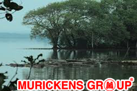
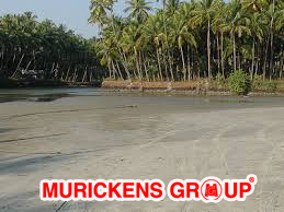
Situated near the St.Angelos Fort, the Mapila bay has a historical background. Centuries ago, it was the seat of Kolathiri Kings. The Kadalayi Fort and Sree Krishna Temple were quite famous. The remnants of the fort and the temple are still seen in Mapila Bay.
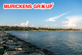 A fishing harbour, built with Indo Norvegian project assistance, is there in this bay. Boating in the sea, if the weather permits, will be an unforgettable experience.Mappila Bay (or Moppila Bay) is a natural harbor situated in Ayikkara Kannur town, Kerala state of South India. On one side ofthe bay is Fort St. Angelo, built by the Portuguese in the 15th century and the other side is the Arakkal Palace.Mappila Bay, or Mopila Bay, is a natural harbour located in the city of Kannur in Kerala. In its past, the Mappila Bay served as a major port, connecting the Malabar to lands far and wide. The Bay is surrounded by some colonial-era architecture,There's also the Arrakulam Palace and Museum on the other side of the harbour, dedicated to the Arakulam kingdom that ruled the Cannanore city-state in the 1500s.
The Mappila Bay serves more like a fishing harbour than an exciting tourist destination. There are boating facilities that will take you around the harbour. However, it is advisable to stay only in the inland waters and avoid the coastal waters, that can turn unfavourable as the weather changes.
The bay was famous during the Kolathiri's regime as a commercial harbour that linked Kolathunadu with Lakshadweep and foreign countries, in imports.
A fishing harbour, built with Indo Norvegian project assistance, is there in this bay. Boating in the sea, if the weather permits, will be an unforgettable experience.Mappila Bay (or Moppila Bay) is a natural harbor situated in Ayikkara Kannur town, Kerala state of South India. On one side ofthe bay is Fort St. Angelo, built by the Portuguese in the 15th century and the other side is the Arakkal Palace.Mappila Bay, or Mopila Bay, is a natural harbour located in the city of Kannur in Kerala. In its past, the Mappila Bay served as a major port, connecting the Malabar to lands far and wide. The Bay is surrounded by some colonial-era architecture,There's also the Arrakulam Palace and Museum on the other side of the harbour, dedicated to the Arakulam kingdom that ruled the Cannanore city-state in the 1500s.
The Mappila Bay serves more like a fishing harbour than an exciting tourist destination. There are boating facilities that will take you around the harbour. However, it is advisable to stay only in the inland waters and avoid the coastal waters, that can turn unfavourable as the weather changes.
The bay was famous during the Kolathiri's regime as a commercial harbour that linked Kolathunadu with Lakshadweep and foreign countries, in imports.
A place of historical importance Ezhimala ( Elimala) was the seat of Mooshika kings in the early periods. Ezhimala has found a place in the travelogues of Iban Bathutha and Marcopolo.
 Ezhimala is also considered to be a treasure chest of medicinal herbs, situated 286m, above sea level, it is a landmark to mariners, and is blessed with a long beautiful beach.The place is shortly going to find strategical importance in the Naval map of India. Ezhimala is situated 45 Km. north of Kannur.Ezhimala, a hill reaching a height of 286 metres, is located near Payyanur, in Kannur district of Kerala, south India. It is a part of a conspicuous and isolated cluster of hills, forming a promontory, 38 km north of Kannur (Cannanore) .
As the former capital of the ancient Mushika Kingdom, Ezhimala is considered to be an important historical site. A flourishing seaport and center of trade around the beginning of the Common Era, it was also one of the major battlefields of the Chola-Chera Wars, in the 11th century. It is believed by some that Lord Buddha had visited Ezhimala.Ezhimala, which is part of Ramanthali panchayath, is one of the most important places in the recorded history of north Malabar. From before the period of known history, some chapters of the Ramayana and local Hindu legends associate the Ezhimala Hills with the famous epic, in particular with lord Hanuman
Ezhimala is also considered to be a treasure chest of medicinal herbs, situated 286m, above sea level, it is a landmark to mariners, and is blessed with a long beautiful beach.The place is shortly going to find strategical importance in the Naval map of India. Ezhimala is situated 45 Km. north of Kannur.Ezhimala, a hill reaching a height of 286 metres, is located near Payyanur, in Kannur district of Kerala, south India. It is a part of a conspicuous and isolated cluster of hills, forming a promontory, 38 km north of Kannur (Cannanore) .
As the former capital of the ancient Mushika Kingdom, Ezhimala is considered to be an important historical site. A flourishing seaport and center of trade around the beginning of the Common Era, it was also one of the major battlefields of the Chola-Chera Wars, in the 11th century. It is believed by some that Lord Buddha had visited Ezhimala.Ezhimala, which is part of Ramanthali panchayath, is one of the most important places in the recorded history of north Malabar. From before the period of known history, some chapters of the Ramayana and local Hindu legends associate the Ezhimala Hills with the famous epic, in particular with lord Hanuman
Thalassery Fort 20 Kms away from Kannur was built on 20th August 1708, on a small hill called Thiruvallappad kunnu. This fort was a formidable stronghold in the past. There are several important tourist centres in Thalassery.
 The Church built beneath the Walls of the Fort with funds left by the Master attendant Mr. Edward Brennen and the large mosque known as Odathil Palli attracts several people. The Thiruvangad temple other wise known as brass Pagode, is dedicated to Sree Rama, Sree Jaganath Temple is next in importance. This temple dedicated to Siva was consecrated in February 1908 AD by the great religious reformer Sree Narayana Guru.Tellicherry Fort is in Thalassery (Tellicherry) a town in Kannur District of Kerala state in south India. Tellicherry was one of the most important European trading centers of Kerala. The Fort lies on the group of low wooden hill running down to sea and protected by natural waters. It has been the main opening for the rich spices, hill products and timber of the vast inter-land.The Tellicherry fort over looking the sea, raises to height of 10m and it is oblong on pian. It was built out of laterite blocks with high round holed walls and strong flanking basetions. The small redoubts on most of the out playing hills have long since disappeared, but Tellicherry fort is in fair state of preservation. The square fort, with its massive walls, strong flanking bastions, secret tunnels to the sea and intricately carved huge doors, is an imposing structure. A light house marks the site of an old redoubt. The fort was once the nucleus of Thalassery's development. Tellicherry was also famous for the cricket match played between the Europeans and local teams in the town near the seashore, which used to attract enormous crowds during those days. This is a centrally protected monument under the control of Archaeological Survey of India since 1921.
Malayalees cannot forget Herman Gundert and his contributions to the Malayalam Language. A German by birth Gundert resided at Illikkunnu Bungalow near Thalassery which was his workshop for 20 years from 1939 for his research activities.
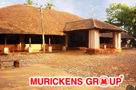 Gundert Bungalow, a popular heritage building and a tourist attraction, is located about 20 km from Kannur. The bungalow lies on a beautiful hill namedIllikkunnu, near Thalassery town, and a river passes through the area making it an absolute visual treat.
This bungalow was the residence of Dr. Herman Gundert who lived here from 1839 carrying out his literary, scholarly and missionary activities. Gundert was a renowned German missionary and scholar who brought out the very first Malayalam English dictionary. He is also credited with the publication of Rajyasamacharam the first Malayalam Newspaper and another publication named Paschimodayam.Gundert Bungalow, where Gundert lived for about 20 years, is considered as a place of historic and cultural significance. Nettur Technical Training Institute (NTTF), Gundert Memorial Church and a cemetery are located close to the bungalow. The building is an excellent piece of architecture built in typical English style and the surroundings of the bungalow are both serene and scenic.
Gundert Bungalow, a popular heritage building and a tourist attraction, is located about 20 km from Kannur. The bungalow lies on a beautiful hill namedIllikkunnu, near Thalassery town, and a river passes through the area making it an absolute visual treat.
This bungalow was the residence of Dr. Herman Gundert who lived here from 1839 carrying out his literary, scholarly and missionary activities. Gundert was a renowned German missionary and scholar who brought out the very first Malayalam English dictionary. He is also credited with the publication of Rajyasamacharam the first Malayalam Newspaper and another publication named Paschimodayam.Gundert Bungalow, where Gundert lived for about 20 years, is considered as a place of historic and cultural significance. Nettur Technical Training Institute (NTTF), Gundert Memorial Church and a cemetery are located close to the bungalow. The building is an excellent piece of architecture built in typical English style and the surroundings of the bungalow are both serene and scenic.
On the way to the Parassinikkadavu Temple, 16 Kms from Kannur, is the Snake Park, the only one of its kind in the state. The snake Park set up by the Visha Chikista Kendra at Pappinisseri, has been a centre of attraction to both foreign and domestic tourists.
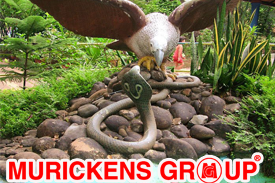 This Kendra offers effective treatment for snakebites with almost hundred percent cures. This is the only place, perhaps where Ayurveda and Allopathy are effectively combined for curing snakebitesThe Parassinkkadavu Snake Park is located in Anthoor Municipality about 16 kilometres (9.9 mi) from Kannur Corporation in the Kannur district of north Kerala, in south India. The Snake Park is in Parassinikkadavu, which is 2 kilometres (1.2 mi) from National Highway (NH) 17, en route from Kannur to Taliparamba,The park houses a variety of snakes and other small animals, including the Spectacled Cobra, King Cobra, Russell's viper, Krait and various pit vipers. There is also a large collection of non-venomous snakes including pythons. The park is dedicated to the preservation and conservation of snakes, many species of which are gradually becoming extinct. In a live show, trained personnel play and 'interact' with a variety of snakes, including cobras and vipers, and try to quell mythical fears and superstitions about snakes.[citation needed] It has also been proposed that a laboratory to extract venom from snakes for purposes of research be set up here.Pappinisseri Visha Chikitsa Society (Snake Bite Treatment Center) was started in the year 1964 at Pappinisseri, Kannur, Kerala with an intention to treat the ailing especially those suffering from snake envenomation. This institution is commemorated on behalf of the Late Sri. C.P. Kumaran Vaidyar and functions as the center for advanced clinical Research and literary documentation in Agada Tantra. Ever since its inception in 1964 it had the monopoly in treating snake bite cases and more than a million snake bite cases were treated and clinically documented.
Famous for timber trade, Valapattanam, situated about 8 k.m north of Kannur has a pride of place in the world map for its wood based industries. Valapattanam was once considered third in the world for timber operations.
 Having to depend only on imports of logs, the place today wears a deserted look with Western India Plywoods being the only exception. Azhikkal port, anall weather medium port, is situated very near to Valapattnam.Valapattanam is a small town in the Kannur district, located in the Indian state of Kerala. It is also the smallest panchayath in Kerala.Its area is 2.04 sqr Km. It is about 7 km north of Kannur. Valapattanam is an important Muslim settlement area in Kannur.Valapattanam is known for its communal harmony. On one side Kalarivathukkal Temple is located and on the other bank there is "Kakkulangara Mosque".This town is also known as Balyapattanam. This town is in the on the banks of Valapattanam river Centuries back Valapattanam River was the main ship route for trading and Valapattanam was the main town, because of this the town got this referred as "Valya pattanam" which means "big town" in Malayalam language.This town is named after its historical founder Vallabha II of the Mooshika dynasty (Kolathiri family) and was originally known as Vallabha-Pattanam and served as the capital of the Mooshika dynasty during the medieval ages. The fourteenth-century narrative of Ibn Battuta refers to the ruler of Ezhimala as residing at Baliapatanam[2] and offers a clue that by this time, the centre of the political authority had shifted from Ezhimala to Baliapatanam.
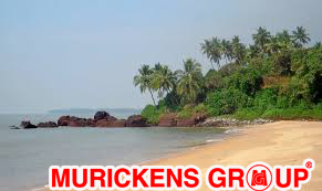
Muzhappilangad beach is situated about 5 k.m. North of Thalassery and 15 k.m. From Kannur. There is an unpaved road winding through coconut groves, leading to the beach. The beach is about 5 k.m. Long and curves in a wide area providing a good view of Kannur beach on the north.
 To the South and about 200 metres away from the beach there is a beautiful island called the "Green Island" which adds to the allure of the beach. Such a conjunction of beach and island is rare.Muzhappilangad Drive-in Beach (5.5 km length)[1] is a beach in the state of Kerala in southwestern India. It is located parallel to National Highway 66(formerly National Highway 17) between Thalassery and Kannur.This beach is the longest Drive-In Beach in Asia and is featured among the top 6 best beaches for driving in the world in BBC article for Autos.Muzhappilangad is the only Asian beach featured in the list. Even though Goa has many beautiful beaches, it does not have a Drive-in beach. It is considered as the longest drive-in beach in Asia.
The beach festival is celebrated in the month of April and it is one of the important tourist attraction in the district of Kannur in Kerala. The youth also try many driving stunts in cars like drifting and wheeling in bikes as this is a paradise for driving along the shore.
There is an unpaved road winding through coconut groves leading to the beach. To get to this road, if you are driving from Tellicherry towards Kannur, take the left turn just before the first railway crossing you encounter after crossing the Moidu bridge. The beach is about 5 km long and curves in a wide area providing a good view of Kannur on the north. Local laws allow beachgoers to drive for a full 4 km directly on the sands of the beach. The beach is bordered by black rocks, which also protect it from the stronger currents of the ocean. These rocks provide habitat for Blue mussel, a delicious seafood. Beach attracts bird-watchers from far off places as hundreds of birds flock here during various seasons.
To the South and about 200 metres away from the beach there is a beautiful island called the "Green Island" which adds to the allure of the beach. Such a conjunction of beach and island is rare.Muzhappilangad Drive-in Beach (5.5 km length)[1] is a beach in the state of Kerala in southwestern India. It is located parallel to National Highway 66(formerly National Highway 17) between Thalassery and Kannur.This beach is the longest Drive-In Beach in Asia and is featured among the top 6 best beaches for driving in the world in BBC article for Autos.Muzhappilangad is the only Asian beach featured in the list. Even though Goa has many beautiful beaches, it does not have a Drive-in beach. It is considered as the longest drive-in beach in Asia.
The beach festival is celebrated in the month of April and it is one of the important tourist attraction in the district of Kannur in Kerala. The youth also try many driving stunts in cars like drifting and wheeling in bikes as this is a paradise for driving along the shore.
There is an unpaved road winding through coconut groves leading to the beach. To get to this road, if you are driving from Tellicherry towards Kannur, take the left turn just before the first railway crossing you encounter after crossing the Moidu bridge. The beach is about 5 km long and curves in a wide area providing a good view of Kannur on the north. Local laws allow beachgoers to drive for a full 4 km directly on the sands of the beach. The beach is bordered by black rocks, which also protect it from the stronger currents of the ocean. These rocks provide habitat for Blue mussel, a delicious seafood. Beach attracts bird-watchers from far off places as hundreds of birds flock here during various seasons.
Anjarakandy 19 K.m. South east of Kannur, is famous for the Cinnamon estate located there, and the oil being extracted from it. The place has historical importance too as Pazhassi Raja and the British Army fought for the estate in 1903.
 Anjarakandy is a gram panchayat in Kannur district of Kerala, India. Anjrakandy river is flowing through Anjarakandy.The village includes Anjarakandy Cinnamon Estate, established by the East India Company in 1767.The estate, reputed to be Asia's largest, and the associated processing plant are still operational. Visitors are permitted to view the process of preparing cinnamon spice and extraction of oil. The local king, Pazhassi Raja and the British East India Company waged war for control of the estate.Lord Brown of east India Company Started a system of keeping a record of Land transactions done by him to open Anjarakandy Cinnamon estate triggered opening up of a new Department of Land Registration in British Government in Asia region, This Land Registrar's office is located at Anjarakandy in a 252-year-old building built in 1767 .The village includes Ancharakandy Cinnamon Estate, established by the East India Company in 1767.The estate, reputed to be Asia's largest, and associated processing plant are still operational and visitors can view the process of preparing cinnamon spice and extraction of oil. In 1803, the local king, Pazhassi Raja and the British Army waged war for control of the estate.
Asia's first Land Registrar's office is located in a 252-year-old building built in 1767 by Lord Brown.The Kannur medical college, established in 2006, is equipped with a 500-bed super-specialty hospital. and Kannur dental college and super specialty hospital, Malabar institute of technology were established in 2010.
Anjarakandy is a gram panchayat in Kannur district of Kerala, India. Anjrakandy river is flowing through Anjarakandy.The village includes Anjarakandy Cinnamon Estate, established by the East India Company in 1767.The estate, reputed to be Asia's largest, and the associated processing plant are still operational. Visitors are permitted to view the process of preparing cinnamon spice and extraction of oil. The local king, Pazhassi Raja and the British East India Company waged war for control of the estate.Lord Brown of east India Company Started a system of keeping a record of Land transactions done by him to open Anjarakandy Cinnamon estate triggered opening up of a new Department of Land Registration in British Government in Asia region, This Land Registrar's office is located at Anjarakandy in a 252-year-old building built in 1767 .The village includes Ancharakandy Cinnamon Estate, established by the East India Company in 1767.The estate, reputed to be Asia's largest, and associated processing plant are still operational and visitors can view the process of preparing cinnamon spice and extraction of oil. In 1803, the local king, Pazhassi Raja and the British Army waged war for control of the estate.
Asia's first Land Registrar's office is located in a 252-year-old building built in 1767 by Lord Brown.The Kannur medical college, established in 2006, is equipped with a 500-bed super-specialty hospital. and Kannur dental college and super specialty hospital, Malabar institute of technology were established in 2010.
Sixty-four K.Ms away from Kannur and 44 K.Ms north east of Thaliparamba lies Pythal Mala the beautiful, calm hillock near the Kerala - Karnataka boarder. 4,500 Ft. above sea level; this hill is abundant in flora and fauna. Trekking 6 Kms would take one to the top of the hill.
 Paithalmala is a hill station in the Kannur district of Kerala in India. Located near Pottenplave village, at a height of 1372 m above sea level, this is the highest geographic peak in Kannur.It is located at 40 km from Taliparamba and 65 km from Kannur.Nestled in the Kerala Karnataka border near to Kodagu forests, it lies in the Western Ghats. It has become a favourite spot for the nature enthusiasts, photographers, trekkers and leisurely visitors.There are two trekking seasons at Paithalmala, falling in monsoon and summer. Monsoon (June to October) trekking to Paithalmala is a photographer's delight as the mist blankets the hills and forest. One can indulge into the lush greenery amidst the showers throughout the day, especially in July. Practically, trekking is not as easy as in the summer because of the extreme climate. Watch out for leeches and occasional elephant visits.
Paithalmala Hilltop: The observatory tower is seen at the extreme
Monsoon is followed by a cool climate in Paithalmala and the grass surrounding the hills grow to their fullest size, making it difficult to walk through. As they grow above seven feet, finding the regular way becomes a difficult task. By December, the forest caretakers set fire to the grass, taking care of the rest of the forest, to ease out the trekking experience. Soon after this, the hill becomes unsuitable to trek because of the black sooth formed but clears away after a couple of weeks. The best time for a trek is from January to March though the sun might be harsh.
Paithalmala is a hill station in the Kannur district of Kerala in India. Located near Pottenplave village, at a height of 1372 m above sea level, this is the highest geographic peak in Kannur.It is located at 40 km from Taliparamba and 65 km from Kannur.Nestled in the Kerala Karnataka border near to Kodagu forests, it lies in the Western Ghats. It has become a favourite spot for the nature enthusiasts, photographers, trekkers and leisurely visitors.There are two trekking seasons at Paithalmala, falling in monsoon and summer. Monsoon (June to October) trekking to Paithalmala is a photographer's delight as the mist blankets the hills and forest. One can indulge into the lush greenery amidst the showers throughout the day, especially in July. Practically, trekking is not as easy as in the summer because of the extreme climate. Watch out for leeches and occasional elephant visits.
Paithalmala Hilltop: The observatory tower is seen at the extreme
Monsoon is followed by a cool climate in Paithalmala and the grass surrounding the hills grow to their fullest size, making it difficult to walk through. As they grow above seven feet, finding the regular way becomes a difficult task. By December, the forest caretakers set fire to the grass, taking care of the rest of the forest, to ease out the trekking experience. Soon after this, the hill becomes unsuitable to trek because of the black sooth formed but clears away after a couple of weeks. The best time for a trek is from January to March though the sun might be harsh.
Kannur is the centre of 'Theyyam' the famous temple folk art form of Northern Kerala. The word Theyyam is a corrupt form of 'deivam' in Malayalam, which means God. Theyyam is generally performed in front of the village shrines. Performance of a particular deity according to its significance and hierarchy in the shrine continues for 12 to 24 hours in the intervals. There are a large number of temples in Kannur where Theyyam is performed.

Clad in, colourful traditional costumes, masks, face paintings, head gear, weapons and decorations of tender leaves of coconut the performance of Theyyam is a rare combination of dance and music which reflects the important features of a tribal culture. Theyyam provides a rare cultural treat in the ritual tradition, which no tourist can afford to missFreedom.Theyyam (Teyyam, Theyam, Theyyattam) is a popular ritual form of worship in Kerala, India, predominantly in the Kolathunadu area (consisting of present-day Kasargod, Kannur Districts, Mananthavady Taluk of Wayanad and Vadakara and Koyilandy Taluks of Kozhikode of Kerala) and also in South Canara and Kodagu of Karnataka as a living cult with several thousand-year-old traditions, rituals and customs. The performers of Theyyam belong to the lower caste community in ancient caste structure formed by Namboothiri brahmins in Kerala, and have an important position in Theyyam. The people of these districts consider Theyyam itself as a channel to a God and they thus seek blessings from Theyyam. Out of devotion, ruling clans established their own shrines and Kavus for Theyyam deities where non-sattvic rituals and customs are observed. The Goddesses like Rakteshwari, Chamundi, Someshwari, Kurathi, and the Gods like Vishnumoorthi are propitiated in these household shrines. There, the Theyyam dancers appear during the annual festivals of Gods and Goddesses. The rituals in such shrines are different from those of the Brahmanical temples. The impact of this cultural fusion could be traced to the social organisation based on the caste system and in the agrarian relations. The inviting of Brahmin Thanthri to consecrate the idols of Kavu is a recent development.
Thalassery is famous for having given birth to many famous circus artists.
 True to this tradition the first circus-training centre has now started functioning in Thalassery, known as the Gymnastic Centre, under the Sports Authority of India. Experts from India and abroad work in this centre.Thalassery is famous for having given birth to many famous circus artists. The first circus training center set up under the Sports Authority of India, known as the Gymnastic Center is functioning in Thalassery. Experts from India and abroad are working in this center.Thalassery is famous for having given birth to many famous circus artists. True to this tradition the first circus training centre has now started functioning in Thalassery, known as the Gymnastic Centre, under the Sports Authority of India. Experts from India and abroad work in this centre.
Kannur district has played an important role in all the political movements Of recent times. The Indian National Congress, which was founded in 1885, captured the attention of the people of this district from its very Inception. A district committee came into existence in Malabar in 1908. A branch of the All India Home Rule League, Founded by Dr. Annie Beasant, functioned in Thalassery during this period and among its active Workers were V. K. Krishna Menon.
The decision of the Nagpur Congress to give up constitutional methods of agitation and resort to Non-Violent Non Co-operation as a means of achieving Swaraj,led to widespread boycott of foreign goods, courts of law and educational institutions in Kannur.Mahatma Gandhi and Maulana Shaukat Ali toured the district tocarry the message of the Non-Co-operation and Khilaphat Movements. The Khilaphat movement coincided with the famous Malabar Rebellion of 1921 which was put down by the British with an iron hand.
Kannur district came into the lime light of Kerala politics in May 1928, when the fourth All Kerala Political Conference was held at Payyannur.
MURICKENS GROUP
HO : KOTTAYAM-KADUTHURUTHY
BR : KOTTAYAM- CEMENT JUNCTION
ERNAKULAM-PALARIVATTAM
Real estate cunsulting officials at U.S.A. (Texas & Newyork) & Bombay
Email : mg@murickens.com, murickans@gmail.com